

File:A Swirl of a Day for Phytoplankton (154086).jpg

.jpg)
Captions
Captions
Summary
[edit]| Description |
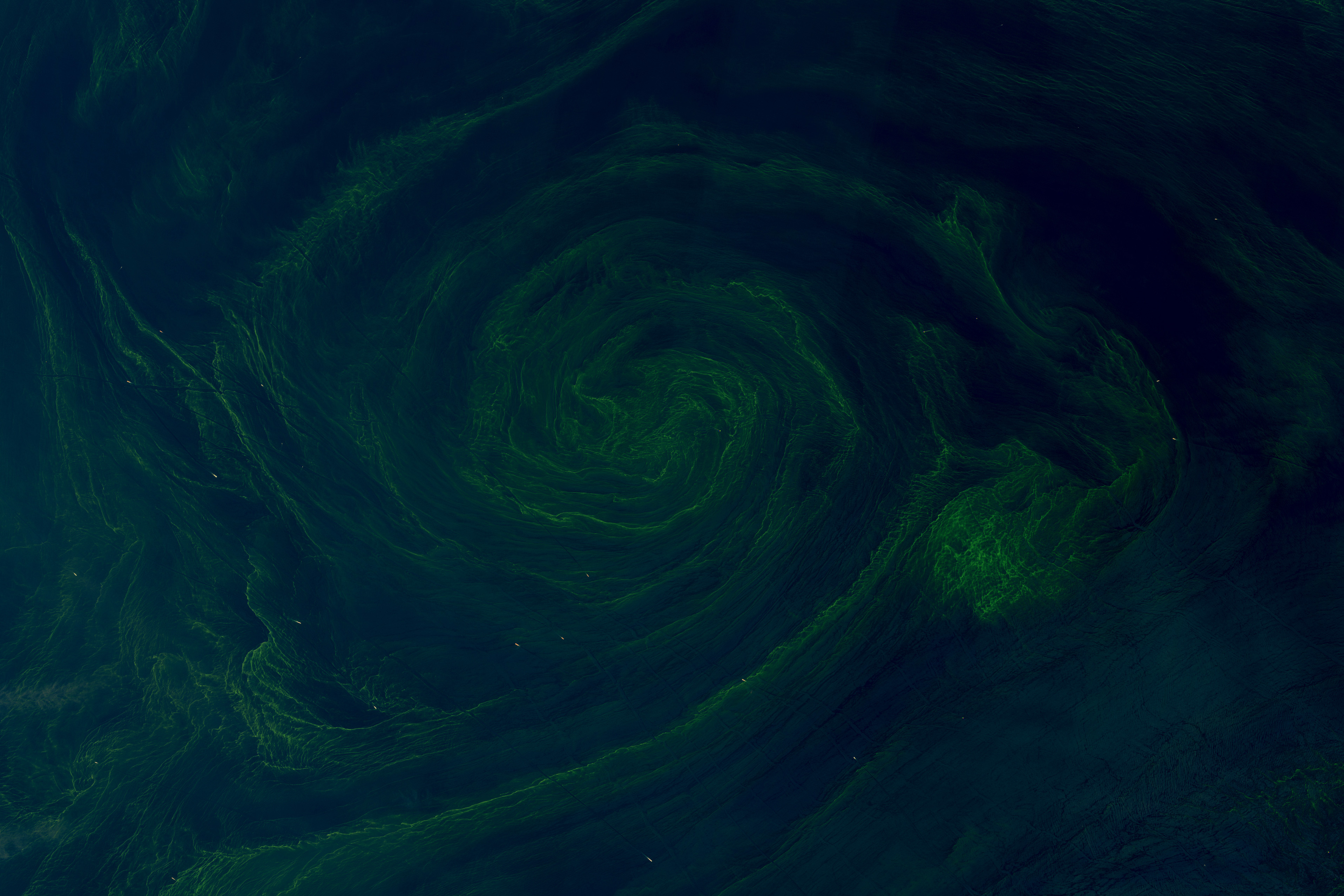
English: The Gulf of Oman is a funnel-shaped body of water between Oman and Iran that connects to the Strait of Hormuz and Persian Gulf to the east and the Arabian Sea to the west. It is a busy hub of international shipping and also supports extensive artisanal fisheries that are important to the economies of several countries in the region.
One notable aspect of the gulf is its frequent blooms of phytoplankton—sharp increases in the population of microscopic plant-like organisms at the base of the aquatic food web. Blooms often occur in a seasonal rhythm when environmental conditions are most conducive to phytoplankton reproduction. The largest blooms in this region typically occur in the winter and early spring (January through March) and the summer (June through August), when water temperatures, light conditions, and nutrient availability are favorable. Monsoon winds are a key driver of winter and early spring blooms because they push surface waters away from the coast and cause an upwelling of cool, nutrient-rich water. Blooming phytoplankton can produce quite a show when viewed from above, sometimes becoming large enough to be visible from space. For much of February and March, multiple NASA satellites observed a bloom that drifted across the Gulf of Oman and into the Arabian Sea. Eddies and currents drew phytoplankton into narrow swirling bands on March 8, 2025, when the OLI (Operational Land Imager) on Landsat 8 captured the images above. The OCI (Ocean Color Instrument) on the PACE (Plankton, Aerosol, Cloud, Ocean Ecosystem) satellite acquired similar images on March 8 and March 24, along with measurements of the concentration of chlorophyll in surface waters. Like plants on land, phytoplankton use chlorophyll and other light-harvesting pigments to carry out photosynthesis, absorbing carbon dioxide to produce sugars for fuel. Chlorophyll in the water changes the way it reflects and absorbs sunlight, allowing scientists to map the amount and location of phytoplankton. The swirls of green likely include Noctiluca scintillans—a type of marine dinoflagellate that has been found here in the past. Though Noctiluca blooms can be beautiful, their presence can have serious consequences for ocean life. Bacteria consume oxygen as they break down the dead phytoplankton, which can cause hypoxia, sometimes depleting oxygen levels enough to kill fish and other marine life. Across the wider Arabian Sea, waters have transitioned in recent decades from supporting abundant diatoms—a type of phytoplankton important for the marine food web—to being dominated by Noctiluca. Unlike diatoms, Noctiluca can thrive in waters that are more stratified and contain fewer dissolved nutrients. This shift has had ripple effects, including an increase in jellyfish and salps, and a decline in copepods and finfish. NASA Earth Observatory images by Wanmei Liang, using Landsat data from the U.S. Geological Survey. Story by Adam Voiland. |
||
| Date | Taken on 8 March 2025 | ||
| Source |
A Swirl of a Day for Phytoplankton (direct link)
|
||
| Author | NASA Earth Observatory images by Wanmei Liang, using Landsat data from the U.S. Geological Survey. Story by Adam Voiland. | ||
| Keywords | Water Color; Image of the Day; Remote Sensing |
.png/120px-Orthographic_view_of_Orion_spacecraft%2C_bottom-front_with_solar_panels_(23128839505).png)
|


.jpg/960px-A_Swirl_of_a_Day_for_Phytoplankton_(154086).jpg)
.jpg/330px-A_Swirl_of_a_Day_for_Phytoplankton_(154086).jpg)
.jpg/1280px-A_Swirl_of_a_Day_for_Phytoplankton_(154086).jpg)
.jpg&action=edit§ion=1)
.jpg)
Licensing
[edit].jpg&action=edit§ion=2)

|
This file is in the public domain in the United States because it was solely created by NASA. NASA copyright policy states that "NASA material is not protected by copyright unless noted". (See Template:PD-USGov, NASA copyright policy page or JPL Image Use Policy.) | .svg/120px-NASA_logo_(2023_colors).svg.png) |
 |
Warnings:
|

|
|
This image is in the public domain in the United States because it only contains materials that originally came from the United States Geological Survey, an agency of the United States Department of the Interior. For more information, see the official USGS copyright policy.
|
 |
File history
Click on a date/time to view the file as it appeared at that time.
| Date/Time | Thumbnail | Dimensions | User | Comment | |
|---|---|---|---|---|---|
| current | 21:52, 25 October 2025 | | 3,833 × 2,555 (1.72 MB) | OptimusPrimeBot (talk | contribs) | #Spacemedia - Upload of https://eoimages.gsfc.nasa.gov/images/imagerecords/154000/154086/omanbloom_oli_20250308_lrg.jpg via Commons:Spacemedia |
You cannot overwrite this file.
File usage on Commons
The following 80 pages use this file:
- User:Franz van Duns/Sandbox
- User:Sophie Österberg (WMSE)/nyflip
- User talk:Don-vip/Archive 22
- User talk:Pine
- Commons:Featured picture candidates/File:A Swirl of a Day for Phytoplankton (154086).jpg
- Commons:Featured picture candidates/Log/May 2026-2
- Commons:Featured pictures
- Commons:Featured pictures, list
- Commons:Featured pictures/Other lifeforms
- Commons:Featured pictures/af
- Commons:Featured pictures/an
- Commons:Featured pictures/ar
- Commons:Featured pictures/ast
- Commons:Featured pictures/az
- Commons:Featured pictures/ban
- Commons:Featured pictures/be-tarask
- Commons:Featured pictures/bn
- Commons:Featured pictures/br
- Commons:Featured pictures/ca
- Commons:Featured pictures/chronological/2026-A
- Commons:Featured pictures/chronological/May 2026
- Commons:Featured pictures/co
- Commons:Featured pictures/cs
- Commons:Featured pictures/da
- Commons:Featured pictures/de
- Commons:Featured pictures/dv
- Commons:Featured pictures/dz
- Commons:Featured pictures/el
- Commons:Featured pictures/en
- Commons:Featured pictures/eo
- Commons:Featured pictures/es
- Commons:Featured pictures/eu
- Commons:Featured pictures/ext
- Commons:Featured pictures/fa
- Commons:Featured pictures/fi
- Commons:Featured pictures/fr
- Commons:Featured pictures/gl
- Commons:Featured pictures/gsw
- Commons:Featured pictures/gu
- Commons:Featured pictures/he
- Commons:Featured pictures/hi
- Commons:Featured pictures/hr
- Commons:Featured pictures/hu
- Commons:Featured pictures/hy
- Commons:Featured pictures/ia
- Commons:Featured pictures/id
- Commons:Featured pictures/it
- Commons:Featured pictures/ja
- Commons:Featured pictures/ka
- Commons:Featured pictures/km
- Commons:Featured pictures/ko
- Commons:Featured pictures/krc
- Commons:Featured pictures/lb
- Commons:Featured pictures/lzh
- Commons:Featured pictures/mk
- Commons:Featured pictures/ml
- Commons:Featured pictures/mo
- Commons:Featured pictures/ms
- Commons:Featured pictures/nan
- Commons:Featured pictures/nb
- Commons:Featured pictures/nl
- Commons:Featured pictures/oc
- Commons:Featured pictures/pl
- Commons:Featured pictures/pt
- Commons:Featured pictures/pt-br
- Commons:Featured pictures/ro
- Commons:Featured pictures/ru
- Commons:Featured pictures/sk
- Commons:Featured pictures/sl
- Commons:Featured pictures/sq
- Commons:Featured pictures/su
- Commons:Featured pictures/sv
- Commons:Featured pictures/syl
- Commons:Featured pictures/tr
- Commons:Featured pictures/uk
- Commons:Featured pictures/uz
- Commons:Featured pictures/uz-cyrl
- Commons:Featured pictures/vi
- Commons:Featured pictures/yue
- Commons:Featured pictures/zh
File usage on other wikis
The following other wikis use this file:
- Usage on en.wikipedia.org
- Usage on te.wikipedia.org
.jpg&oldid=1216343540)